Conservation Commission
Shelton, Connecticut
 OPEN
SPACE MENU
OPEN
SPACE MENU
Open Space Links
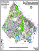
Open Space Map (3mb)
City of Shelton Open Space Marker

This marker is used to identify Public Open Space owned by the City of Shelton. It does not mark the exact location of the property line and may be as much as 100 feet away from the boundary, depending on site conditions. The Conservation and Pedestrian Easements markers have a similar look but different text.
Land Trust Marker

The Land Trust is a private, non-profit group that owns 364 acres of open space in Shelton, marked with these signs. People frequently confuse the Land Trust with the City of Shelton.
Wetlands Marker
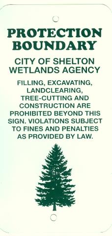
These rectangular wetlands marker may be found in some newer subdivisions, usually on 4x4 posts. They mark the location of areas regulated by the Shelton Inland Wetlands Commission. These are generally on private property and are not related to open space.
OS 1 Coppel Lane, Arthur's Court (0.97 ac.)
Map 9 Lot 26
Features: Most of this property consists of a large wooded swamp located in both Shelton and Stratford which is associated with Black Brook. The brook flows east from the swamp to empty into the Far Mill River near Route 8 Exit 12. There are currently no trails on the open space. A tributary to Black Brook crosses Coppel Lane and feeds into the swamp. The first 150 feet of this feeder stream east of Coppel Lane is located with the open space.
Access: Although there are no trails, the land is open to the public. There are two narrow accessways to the property: A 50-foot wide accessway between houses #4 and #8 Coppel Lane along the west bank of the stream. Note that the stream turns onto private property after about 150 feet. The second accessway is via a 15-foot wide corridor at the end of Arthur's Court.
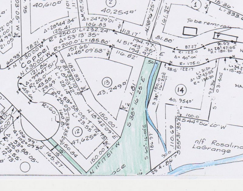
Maps
| Tax Accessor's Map (Click to enlarge) |
 |
| Tax Accessor's map overlay onto aerial. |
 |
| Filed subdivision map |
 |
Deed History
The property was acquired on November 9, 1978 under subdivision regulations that require an open space set-aside. There are no explicit deed restrictions on this property other than a reference to land identified as "open space" on a subdivision map for Blackbrook Estates, filed map #1532. The deed is located at Vol. 372 Page 232.