Conservation Commission
Shelton, Connecticut
 OPEN
SPACE MENU
OPEN
SPACE MENU
Open Space Links
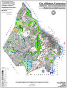
Open Space Map (3mb)
City of Shelton Open Space Marker
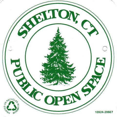
This marker is used to identify Public Open Space owned by the City of Shelton. It does not mark the exact location of the property line and may be as much as 100 feet away from the boundary, depending on site conditions. The Conservation and Pedestrian Easements markers have a similar look but different text.
Land Trust Marker
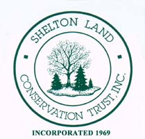
The Land Trust is a private, non-profit group that owns 364 acres of open space in Shelton, marked with these signs. People frequently confuse the Land Trust with the City of Shelton.
Wetlands Marker
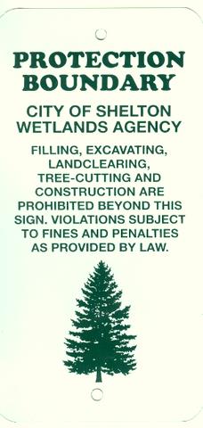
These rectangular wetlands marker may be found in some newer subdivisions, usually on 4x4 posts. They mark the location of areas regulated by the Shelton Inland Wetlands Commission. These are generally on private property and are not related to open space.
OPEN SPACE
The City of Shelton goal is to preserve at least 15% of the land as permanently protected, locally-controlled open space in any of the following forms:
- City of Shelton Public Open Space properties
- Farmland protected by the purchase of development rights
- Shelton Land Conservation Trust properties
As of 2009, these forms of open space total more than 13% of the city, and more than 2,700 acres.
City of Shelton Public Open Space (>1900 acres)
The City of Shelton owns close to 2,000 acres of Public Open Space, which are shown in light green on the Open Space Map (3mb) and labeled with "OS" prefixes. These lands are open to the public from dawn to dusk for passive recreational activities such as hiking, dog walking, biking, kayaking, fishing, picnicking, cross country skiiing, geocaching and letterboxing (See the Recreation page for more info.) Some areas also have ball fields and playgrounds.
Prohibitions include clearing or cutting of vegetation, dumping (including dumping of lawn debris), motorized vehicles (ATVs, dirt bikes, 4wd trucks, boats with combustion engines), hunting, paintball, BB guns (including Air Soft), fires, and camping (see the Open Space Regulations for complete listing).
Generally speaking, the Conservation Commission has day-to-day jurisdiction over the "unimproved" open space properties while the Parks and Recreation Department oversees the "park-like" open spaces that require routine maintenance, such as ballfields, Riverview Park, Sunnyside boat launch, and the Huntington Green. The Trails Committee reports to the Conservation Commission. Some properties adjacent to schools are controlled by the Board of Education but function as open space.
The City's 2009 Open Space Plan identifies management issue, acquisition strategies, and potential uses for open space properties, such as dog parks or community gardens.
Shelton Land Trust Open Space (370 acres)
The Land Trust is a private organization that owns 364 acres of open space in Shelton. The group allows public access to these properties and maintains several hiking trails and a youth camp. Their properties are shown on the City's open space map in dark green and with "LT" prefixes, as well as on the Land Trust's website.
Protected Farmland (411 acres)
The City of Shelton has acquired agricultural conservation easements over the following properties in the White Hills: Jones Family Farms (Homestead Acres, Pumpkinseed Hill, and Valley Farm), Shelton Family Farm, Beardsley Organic Farm; Stockmal Woods; and Little Knoll. These easements preclude housing developments but allow farming activities. The properties remain privately owned and are not normally open to the public except as advertised by the farmer (generally for pick-your-own crops).
Other Types of "Open" Lands
The following types of open land are not included in the City's 15% goal, but contribute to the City's character:
- State of Connecticut conservation properties (437 acres), including Indian Well State Park and various conservation properties purchased from Aquarion in 2002. Open to the public.
- Aquarion properties protected by conservation easement (700 acres). These lands are not open to the public at this time, but there is potential for limited public access on some properties.
- Aquarion properties not protected by conservation easement (418 acres). Not open to the public.
- Golf Courses (142 acres). These are not protected from development. Open to golf club members only.
- Cemeteries (44 acres).
- Shelton Canal (4 acres). Open to the public under McCallum Enterprise's 1986 license to generate hydroelectric power at the Derby-Shelton dam.
Vacant Lands
About 3,000 acres, representing nearly 15% of the City, are "vacant" or "underdeveloped". These are unprotected lands that are currently forested or farmed, but which may be subdivided into housing tracts. Such land is sometimes referred to as "perceived open space" because residents get the feeling that it is open space until the land is developed.