Conservation Commission
Shelton, Connecticut
 OPEN
SPACE MENU
OPEN
SPACE MENU
Open Space Links
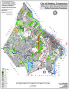
Open Space Map (3mb)
City of Shelton Open Space Marker
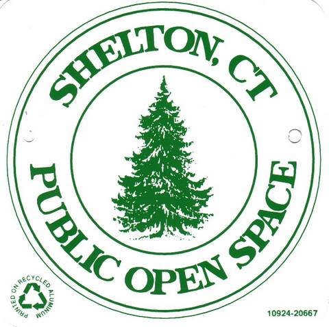
This marker is used to identify Public Open Space owned by the City of Shelton. It does not mark the exact location of the property line and may be as much as 100 feet away from the boundary, depending on site conditions. The Conservation and Pedestrian Easements markers have a similar look but different text.
Land Trust Marker
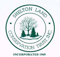
The Land Trust is a private, non-profit group that owns 364 acres of open space in Shelton, marked with these signs. People frequently confuse the Land Trust with the City of Shelton.
Wetlands Marker
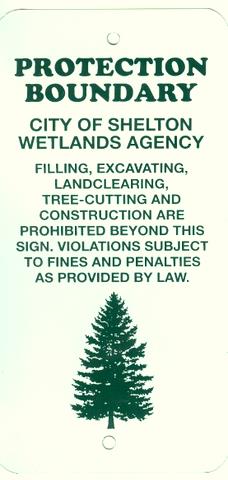
These rectangular wetlands marker may be found in some newer subdivisions, usually on 4x4 posts. They mark the location of areas regulated by the Shelton Inland Wetlands Commission. These are generally on private property and are not related to open space.
Landkeeper Program
Shelton Landkeepers adopt an Open Space property of their choosing, often one near their home.
Ideally, Landkeepers fill out a Landkeeper Reporting Form once a year and send that to the Conservation Commission, however, the program is flexible. Scout groups are often looking for a one-time-event, such as a park clean-up. Or some individuals may simply want to walk the property once in a while and let us know if you see any problems (this can be a big help in areas with certain types of problems such as ATVs or paintball). These are all forms of landkeeping.
Patch Program
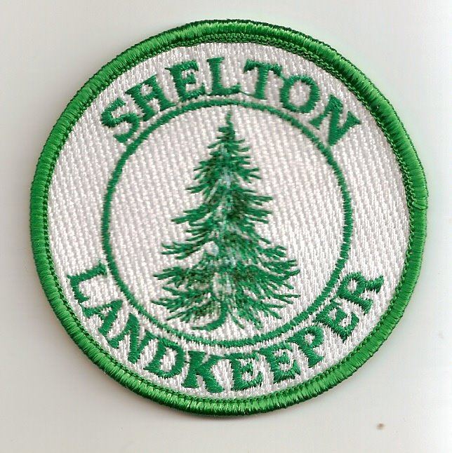 A Landkeeper
patch will be awarded to volunteers who have submitted a
Landkeeper Reporting Form and either:
A Landkeeper
patch will be awarded to volunteers who have submitted a
Landkeeper Reporting Form and either:
1. Adopted the open space property for one year and kept an eye on it by periodic walks (for Scout or school groups, this may be the better part of a school year) OR
2. Taken some substantial action to improve an open space property, such as holding a clean-up event to pick up trash.
To obtain the patches, indicate the number of patches you need at the bottom of the Reporting Form.
The property must be land managed by the Conservation Commission. These are generally wooded properties, or portions of parks that are wooded.
Note: Picking up trash during one hike is a great thing to do, but does not qualify one for the patch program, unless it is done several times during the year.
Common Questions
What Open Space should I choose? Many Landkeepers simply pick an open space they are already familiar with. If you do not have a property in mind, you can look at the CIty open space maps to located one of interest. Note the "OS" or "LT" number for that property. If it is labeled "LT", it is owned by the Shelton Land Conservation Trust, a private organization that also uses Landkeepers. You can also email the Conservation Agent and ask for suggestions. Some current suggestions:
Riverview Park OS47 - A hiking trail is located part way down the embankment and there is always lots of garbage that needs picking up. See sheltontrails.org for maps and info about this property.
East Village Park OS51 - Trash from the ballfields blows down into the woods.
Gristmill Trail OS 92 - Mill Street - Scenic Far Mill River and short trail often need trashed picked up.
Birchbank Mtn OS 94 - A very scenic "party" location near Okenuck Way and Little Fox Run usually needs cleaning. Close to the Paugussett "Blue Dot" Trail.
Abbey Wright OS 27.04 - Nells Rock Road Parking Area across from L'Hermitage Condos frequently needs cleaning.
Huntington Wellfield OS 90 - Huntington
Street across from Maple Lane, west of Far Mill River.
Problems with partying, paintball, and dirtbikes.
Where can I get information about my adopted open space? Some open space properties are described on this website, but for many others this information must be obtained by the Conservation Agent: 924-1555 x1315, room 102 City Hall, conservation@cityofshelton.org. By request, information can be added to this website.
There are kids on ATVs, shooting BB guns, (etc). What should I do? Do not get drawn into a confrontation. Note as much detail as you can. If possible, take photographs, but do not endanger yourself. The realization that people are taking their pictures often works better to reduce illegal activity than anything else, especially since such photos could be posted on the Internet. Call the Police Department and note their response. Document as much as possible and forward this information to the Conservation Agent. It is especially valuble if you can determine where the offenders live. The Conservation Agent can send a certified letter to the homeowner. In addition, if enough evidence is collected, the City can file suit against the offenders or their families.
I have some ideas for park improvements. What should I do? Great! Share your ideas with the Conservation Agent. If this is something you would be willing to work on yourself, then we will help obtain the necessary approvals. You can ask the Conservation Commission to fund your project if materials are involved, or ask local businesses for donations. Examples of park improvements include the removal of invasive species, trails, benches, signs, parking areas, fences and plantings.
We picked up a mountain of trash and left it by the side of the road. Will the City pick it up? Yes, but you need to notify Highways and Bridges 924-9277 and let them know that the garbage is there and why it is there. Allow a week for the trash to be picked up. If you have any difficulties, contact the Conservation Agent.