Conservation Commission
Shelton, Connecticut
Our Blogs & Groups:
- Trails Committee Blog
- Eklund Garden Page
- Eklund Garden Blog
- CC Google Group
- Deer Committee Blog
- Litter Committee Blog
- "In the Field" Blog
- Facebook Page

Shelton Land Trust
The Shelton Land Conservation Trust is a private organization often confused with the Conservation Commission. The Land Trust owns 364 acres of private open space that is open to the public, including several trails and a youth camp.
Links
- Shelton Land Trust
- City of Shelton
- Litter Committee
- Ansonia Nature Ctr
- CT Forest & Parks
- Housatonic Valley
Contact
Teresa Gallagher
Natural Resource Manager
(203) 924-1555 x1315
City of Shelton
54 Hill Street
Shelton, CT 06484
(email)
Natural Resource Manager Teresa Gallagher's office is located in Room 102 of City Hall (adjacent to the auditorium). If you need to meet with her, please call first to make sure she will be at her desk.
Trail Blazes
Trail blazes are rectangles of color-coded paint on trees and other objects that mark the trail location. When there are two blazes of the same color, the higher blaze indicates the direction of a turn. Each trail is assigned a blaze color - check your trail map.
Trail Etiquette -
Recreation Path
STAY TO THE RIGHT.
PASS ON THE LEFT.
Pedestrians: Be aware that bicyclists may come up quickly behind you. Please be alert for bikers and maintain room for them to pass on the left.
Bicyclists: Keep your speed down and let pedestrians know you are about to pass.
Dog owners: Please pick up after your pets and make sure your dogs do not run out at other users (use a short leash).
Parents: Make sure your children keep to the right and pass on the left. Children running out in front of bikes is a common source of bicycle accidents.
Hiker Etiquette
Take only pictures, leave only footprints.
Be respectful of neighboring residents. Keep your voices down, dogs on leash, and don't ask neighbors for directions (ask another trail user instead and go prepared with a map).
Neighbors: Please do not allow dogs to bark at trail users, and keep music down.
Do not pick flowers - leave them for others to enjoy.
Keep your voices down (including cell phone calls). Voices carry especially far on the shores of the reservoirs.
Respect fishermen along the reservoirs: keep your voices down and maintain a polite distance between you and the fishermen.
Please pick up litter where you find it.
Technically, hikers have the right of way over mountain bikers. However, it is much easier for a hiker to step out of the way and allow a biker to pass.
Paugussett Trail Etiquette
Blue-Blazed trails often cross private property with only a precarious hand-shake agreement between CFPA and the property owner. The rules and etiquette are therefore very strict:
No bikes or horses on the blue trails (and certainly no ATVs).
Do not stray from the trail unless you are sure you are in a public park and not on private property.
No geocaches or letterboxes on private lands along the trail unless you have permission from the property owner.
Be especially respectful when hiking near private residences. Keep your voices down and dogs on leash.
Be aware that you may pass through areas open to hunting and dress in bright colors during hunting season.
Please pick up any litter left behind by other hikers.
TRAILS
There are about 32 miles of marked hiking trails in Shelton, from the handicapped-accessible Shelton Lakes Recreation Path to the challenging Paugussett "Blue Dot" Trail. Before you head out on a trail, be sure you have a map, know how to read trail blazes, and are familiar with trail etiquette (see margin at right).
TRAIL MAP
QUICK LINKS
Scroll down the page for descriptions and additional map formats:
Need a map on your phone for geolocation? Use our
**Custom
Google Map**
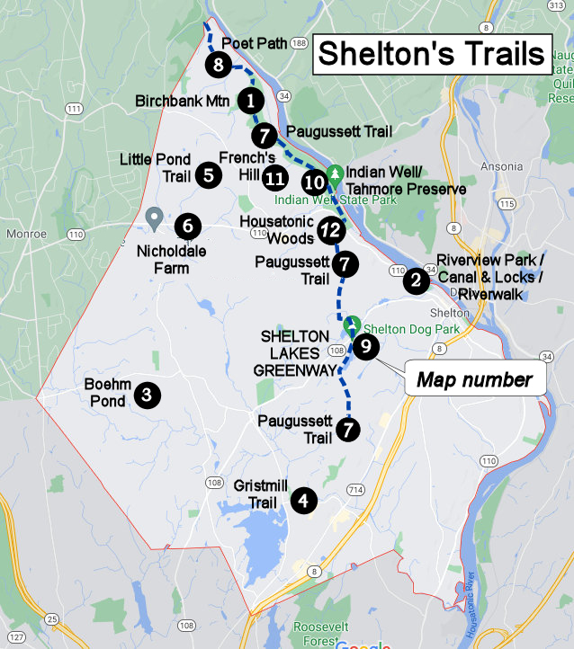
Overview map showing map number (click to enlarge)
1 Birchbank
Mountain
2A Bluff Walk at Riverview Park
2B Shelton Canal & Locks
2C
Riverwalk North
2D
Riverwalk South
3 Boehm Pond
4 Gristmill Trail
5 Little Pond Trail
6 Means Brook
Greenway (Nicholdale Farm)
7 Paugussett Trail Overview
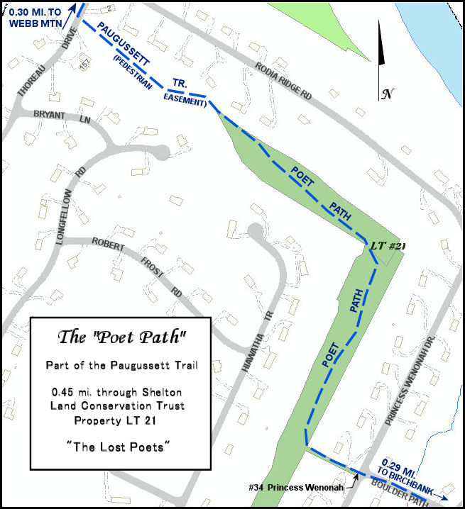
8 Poet
Path
9 Shelton
Lakes Greenway All Trails (Rec Path, Turkey Trot, Nells Rock...).
Close Up Maps: Hope
Lake Trails; Turkey Trot
Trail; Wiacek
Meadows
10
Tahmore Preserve & Indian Well State Park
11 French's Hill
12 Housatonic Woods
(Woodsend Trail)
Maps for our trails can be printed or viewed online (scroll down for additional map format options). You can also track your progress along the trails via our Google Map of Shelton Trails. You must view the map using the Google Map app installed on a smart phone in order see your current location on the trail map. See our blog post for more information about the map and how to view it on your phone.
Trails are created and maintained by volunteers. Visit the Trails Committee's blog to learn about upcoming events, come to work parties, or read the latest trail news.
Shelton Riverwalk
Handicapped Accessible Paved Surface
Located in downtown Shelton at Veteran's Memorial Park, the handicapped-accessible Riverwalk is being extended from the Route 8 bridge north to the Shelton Canal & Locks.
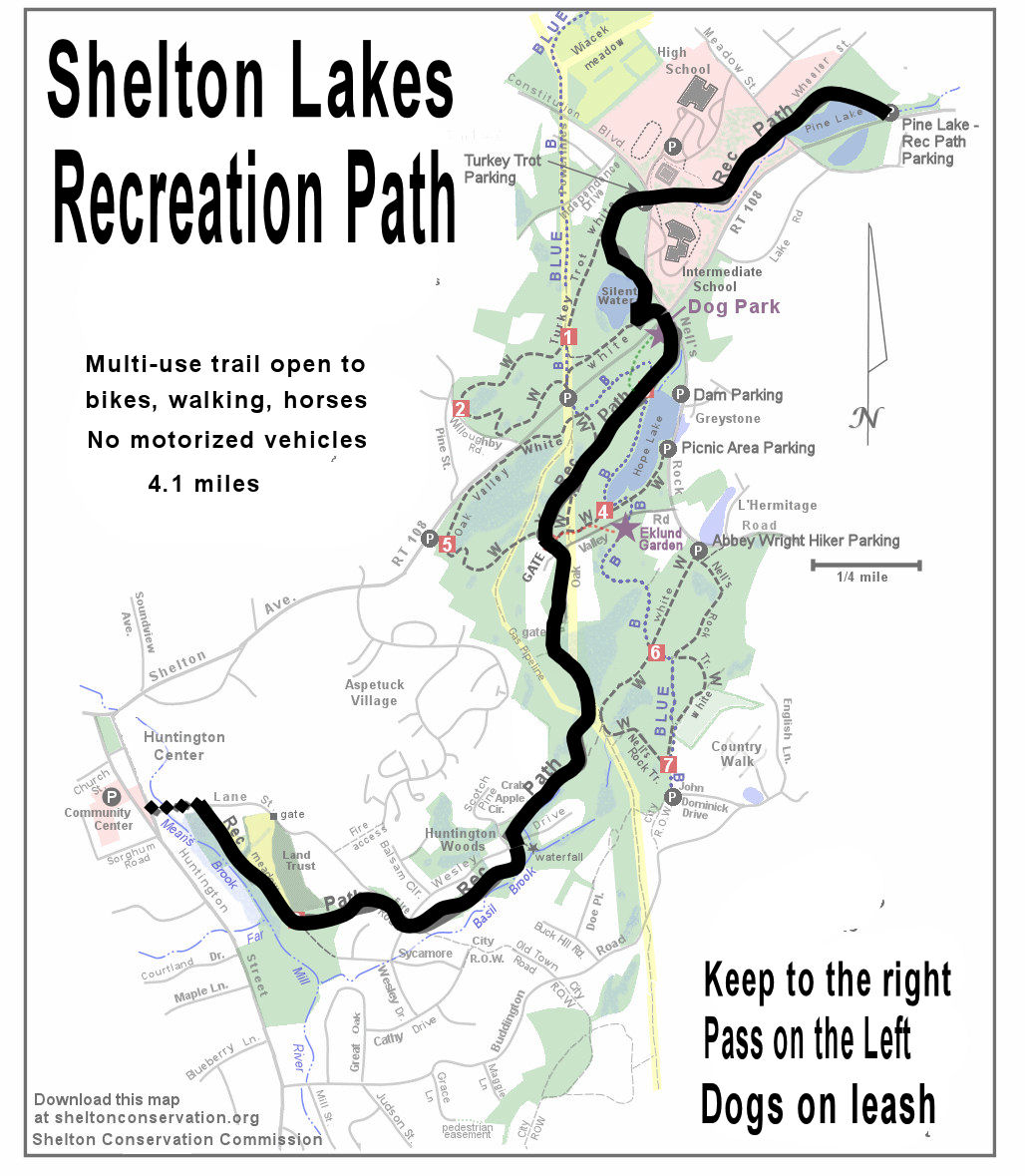
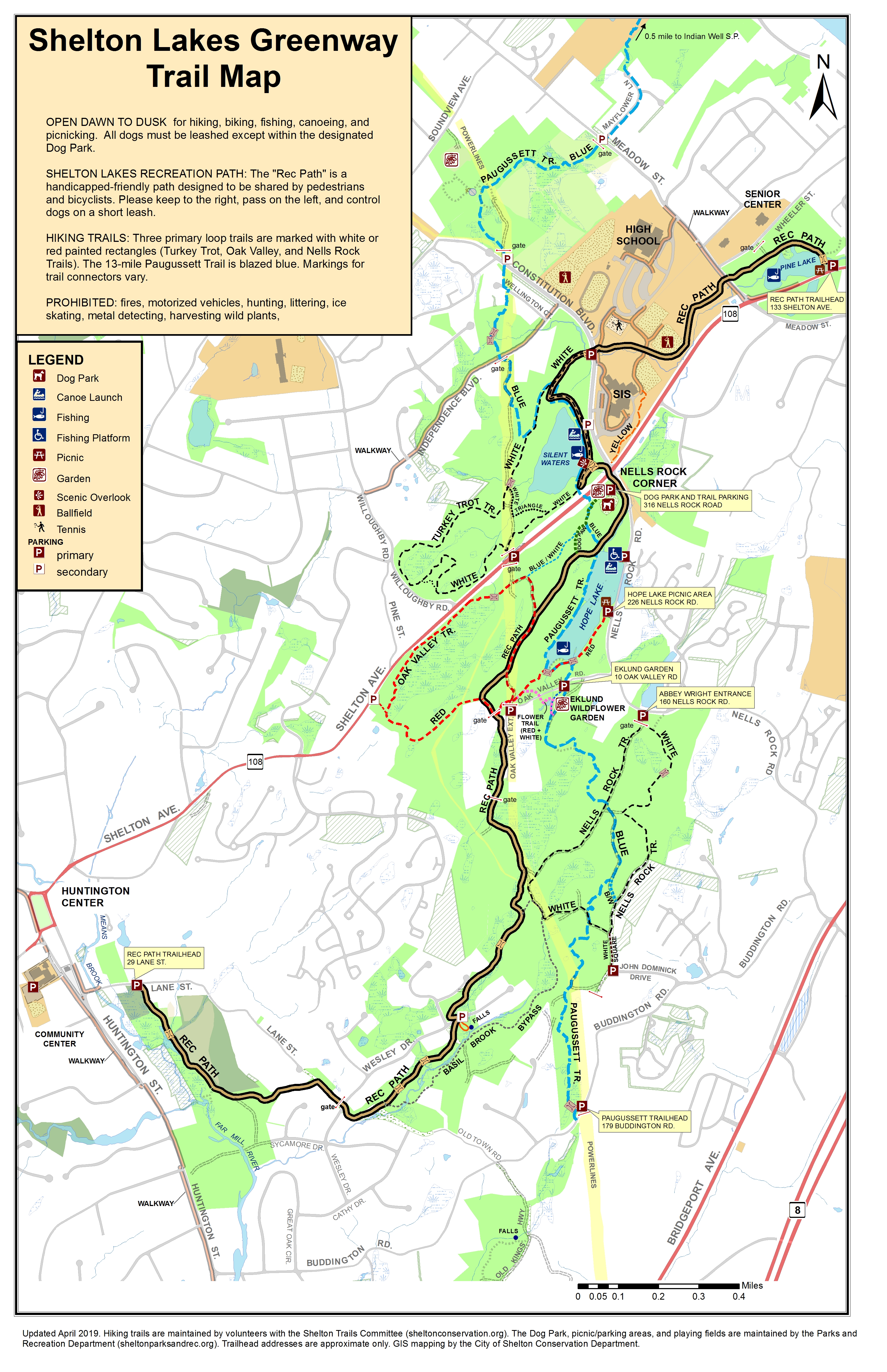
Shelton Lakes Recreation Path
Handicapped Accessible Crushed Stone Surface 4.1 mi.
The
Shelton Lakes Recreation Path ("Rec Path") is a popular multi-use
path located in the Shelton Lakes Greenway suitable for bikes,
baby strollers, and wheelchairs. The path is 8-12 feet wide with a
crushed stone surface and is handicapped accessible. The path was
completed in 2012. Click
HERE
for a map.
The Rec Path northern section begins at Pine Lake (aka
Shelton Reservoir #2) on Shelton Avenue Rt. 108 east
of Meadow Street. There is ample parking.
The path heads west up a long but gradual incline
between the Intermediate School and High School,
crosses Constitution Blvd South, and follows the top
of a long dam built in the 1800's at Silent Waters
(aka Shelton Reservoir #1). The Rec Path then crosses
Shelton Avenue at the signal (Mile 1.25), runs past
the new Dog Park to an overlook of the Hope Lake dam,
and continues for another half mile to Oak Valley
Road, and then parallels Oak Valley Road Extension
(Mile 2.0).
After following the powerlines briefly the Rec Path
turns back into the forest, crosses Basil Brook,
crosses Wesley Drive, and begins a long descent to
Huntington Center, crossing Wesley Drive again and
skirting the Land Trust Meadow before ending on Lane
Street not far from Huntington Street (Mile 4.1).
Designated parking in Huntington Center is at the
Community Center.
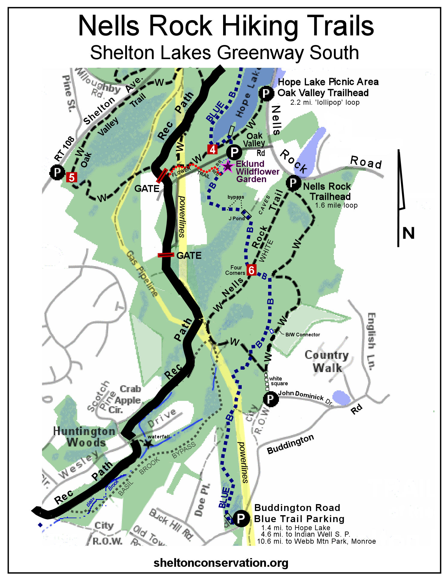
Shelton Lakes Greenway Trail Network
Easy to Moderate, 11+ Miles
[MAP/BROCHURE
11x17 2019 (PDF)]
[MAP 11x17 2019 (JPG)]
[MAP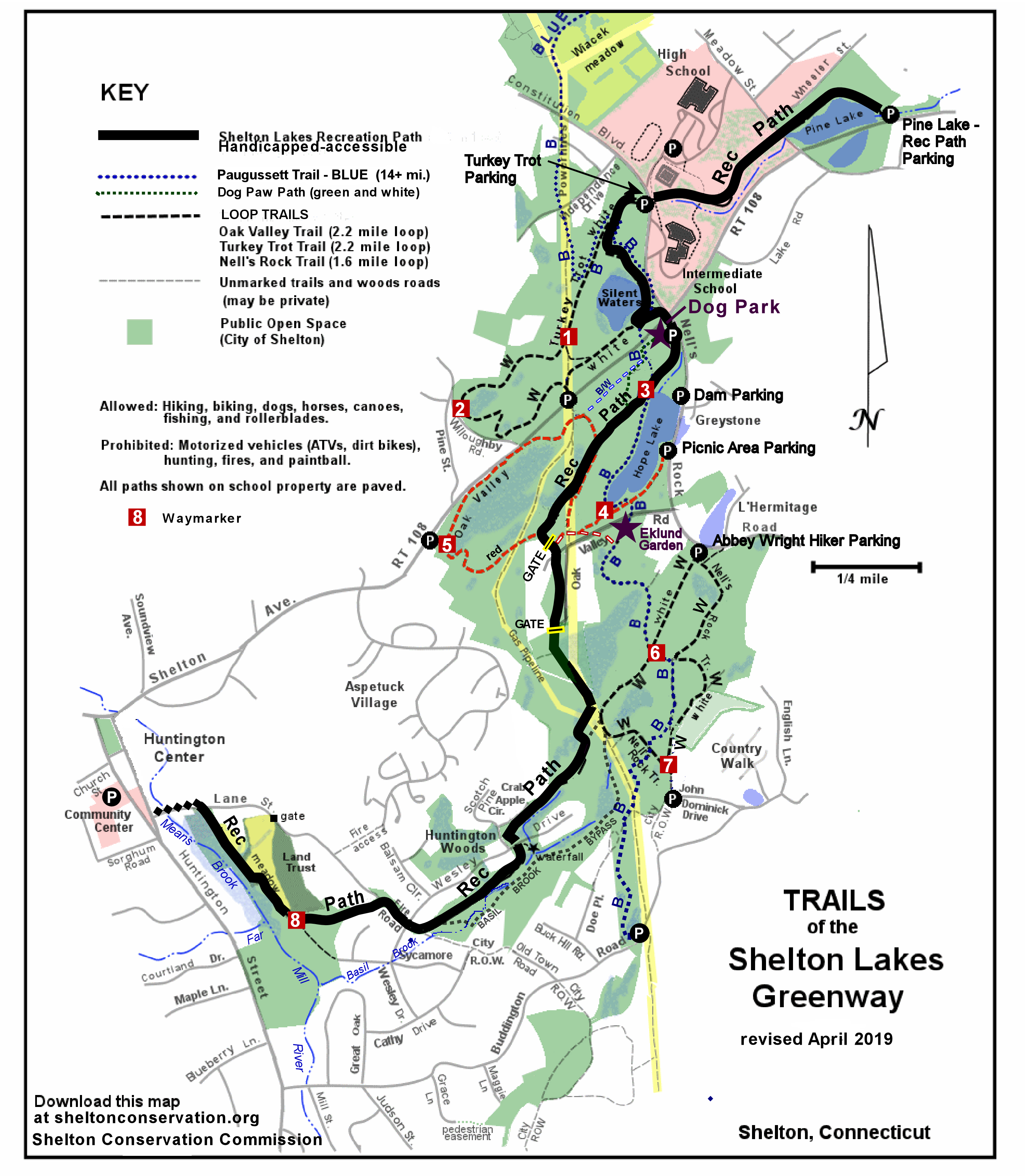 8.5 x 11 2019 (JPG)]
[MAP of Nells Rock
Trails 2017 (JPG)]
[MAP of Nells Rock Trails 2017
(PDF)]
[GPX
file for GPS: You may view this on a smartphone map by installing a
gpx viewer app. This map will show your current location and all the
trails. Save the gpx file onto your phone and open with the app.]
Shelton Lakes
is the most popular place to hike or go mountain biking in Shelton.
Features include three reservoirs, the multi-use Rec Path (see above), miles of hiking
trails, the Dog Park, and Eklund Native Species Garden.
If you go hiking, be sure to bring a trail map, since there are eleven miles of trails (color-coded) spread over 450 acres, and unprepared hikers often become turned around. There are waymarkers on 4x4 posts along the trails that are keyed to the map. There are several access points, but perhaps the most popular is the Hope Lake picnicking area on Nells Rock Road.
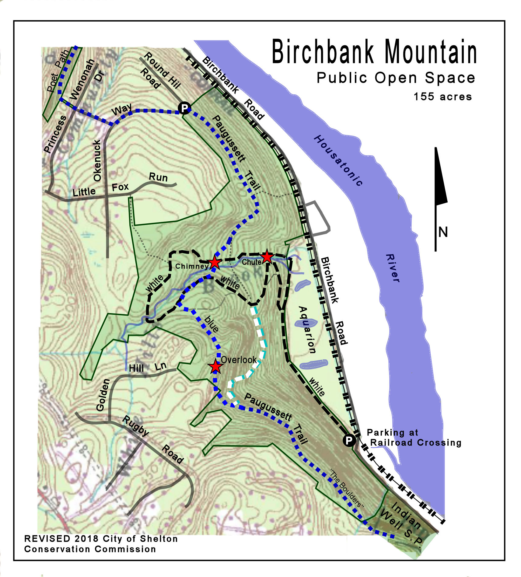
Birchbank Mountain (155 acres)r />
3 miles of hiking trails, moderate to challenging
 [TRAIL
MAP for printing- pdf]
[TRAIL
MAP for printing- pdf]
There are three miles of hiking trails at Birchbank, one of the most remote and rugged areas in Shelton. Bikes are prohibited. April brings a spectacular wildflower display on the lower parts of the trail, and wood ducks have been sighted. Click map to enlarge.
The main trailhead is on Birchbank Road (aka Indian Well Road), 1.0 mile north of the beach parking turnoff for Indian Well State Park. There is parking where the road crosses the railroad tracks. A second parking area is at the intersection of Okenuck Way and Round Hill Road, located in the "Poet" section of the White Hills.
The white-blazed Birchbank Trail (1.5 mile) rises 250 feet, steady but not steep (there were significant reroutes in 2010 that made the trail easier to walk). Part of the trail follows old colonial road beds which lead from former settlements on the Housatonic River up through a notch in the river bank to the White Hills area above. Farmers probably used the road to access Housatonic shipping points and bring their product to market. Native Americans also apparently used the notch and there is evidence of quartz arrow manufacturing. The trail also passes an old chimney from the Monroe Rod and Gun, which burned down several decades ago, and a series of cascades along Upper White Hills Brook.
The Paugussett Trail ("blue dot") crosses Birchbank Mountain from the border with Indian Well State Park to Round Hill Road, a total distance of 1.3 miles. The north end of the trail between Round Hill Road and the scenic vista of the Housatonic River is moderately easy, but south of the vista the trail becomes very rugged. This section includes walks over rockfalls and a scramble over large boulders. This is the most challenging section of trail in Shelton.
The Blue/White Connector trail (0.25 mi.) follows the previous route of the Paugussett Trail (rerouted in 2016) and provides a secondary connection between the Paugussett Trail and Birchbank Trail. A section is of this connector is moderately steep and can be slick with fresh leaves.
Burritt's Bypass was constructed in 2022, allow northbound hikers on the Paugussett Trail to avoid a descent on boulders.
Gristmill Trail on the Far Mill River
Easy 0.3 mile
[TRAIL MAP (pdf)] This short but highly scenic trail provides river access to fishermen and nature lovers alike. The remains of an old mill dam greet visitors near the trailhead, and the trail follows the shoreline in an area that is covered with raging flood waters about once a year. The trail is level, but footing can be uneven. Access is from Mill Street, at the sign kiosk. Click thumbnail map to enlarge.
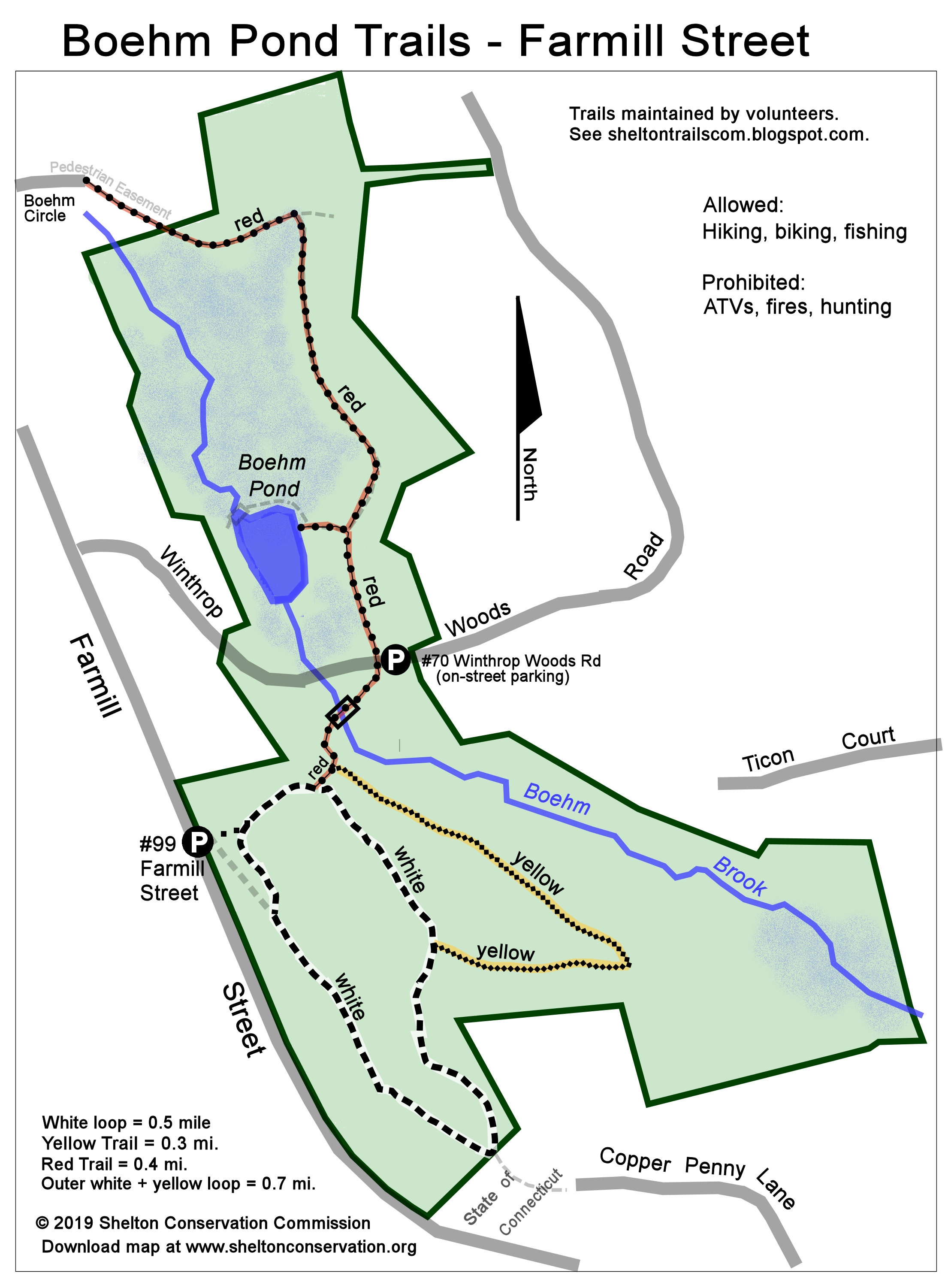
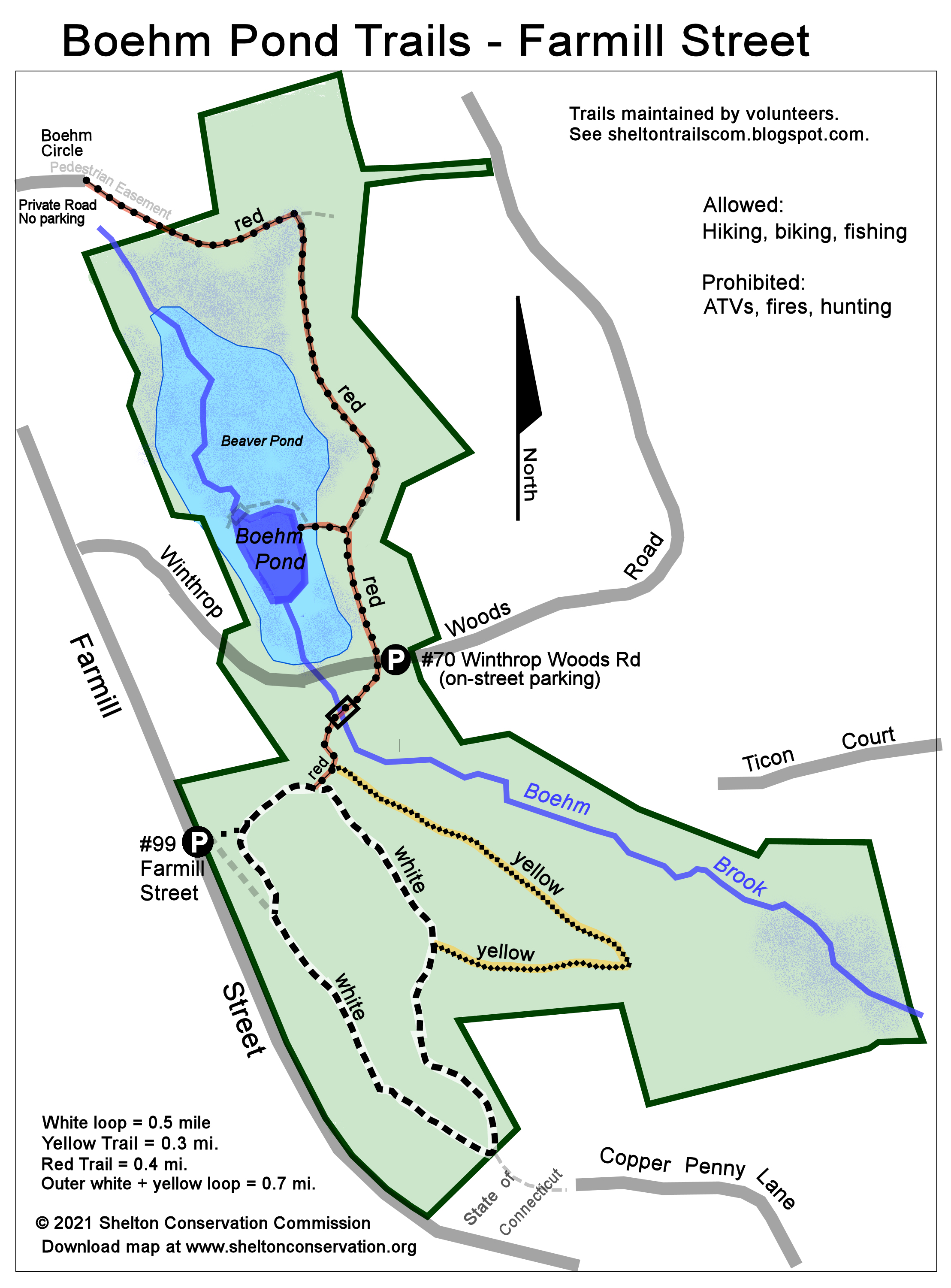
Boehm Pond Trails
Easy to Moderate 1-2 miles
 [TRAIL
MAP (pdf for printing)]
[TRAIL
MAP (pdf for printing)]
[TRAIL MAP
(jpg for cell phones)]
These easy loop
trails lead to a small pond on the
west side of Shelton. A small pull-off is located at #99 Farmill Street
(not Mill Street), and on-site parking is available at #70
Winthrop Woods Road, where the red trail crosses the street. The
latter parking area is accessible during the winter for
snowshoeing or cross-country skiing.
Means Brook Greenway, featuring
Nicholdale Farm, Willis Woods, and Pearmain Preserve Trails
Easy to moderate, several miles
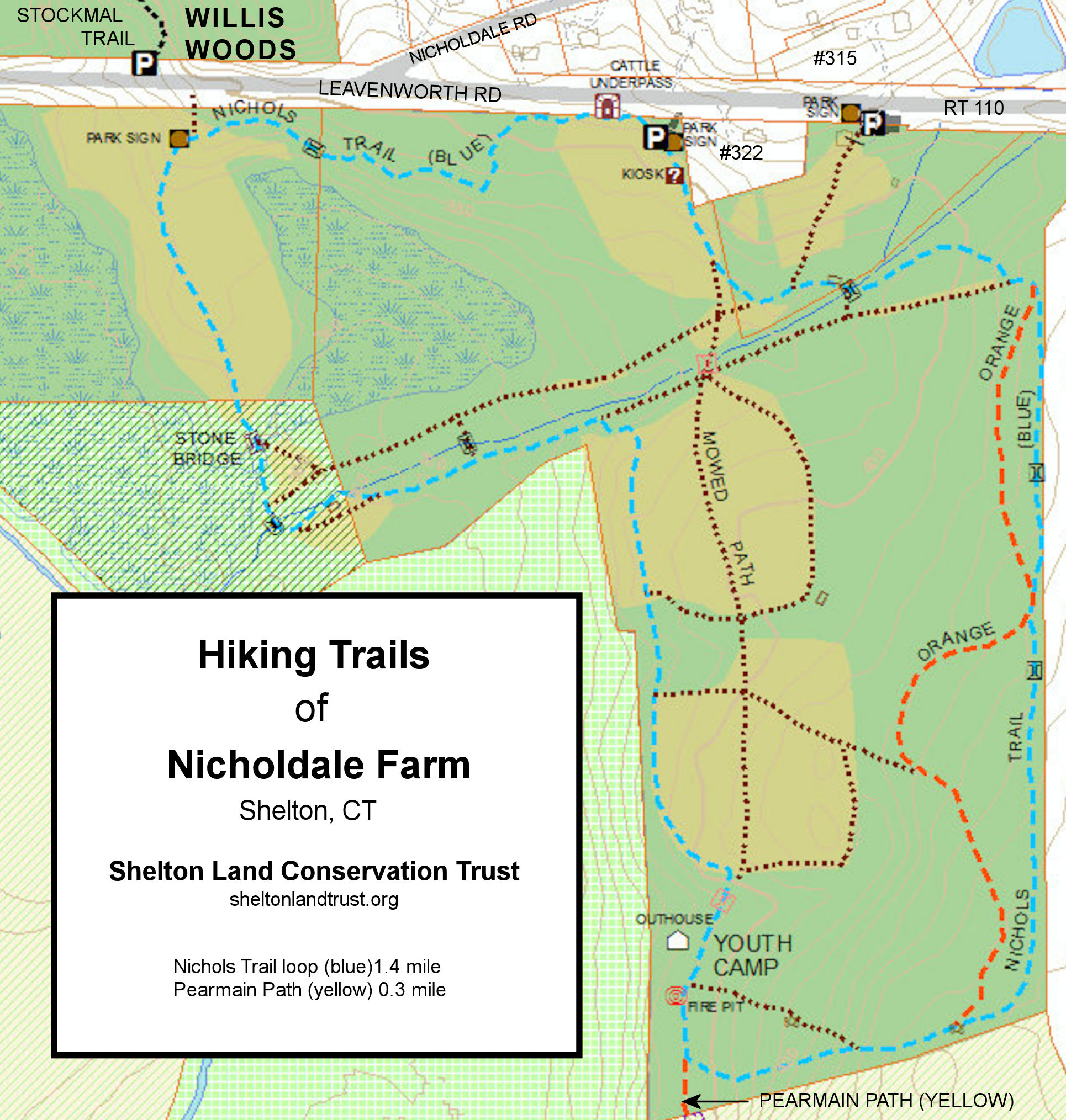 Nicholdale Farm, Willis Woods,
and Pearmain Preserve are located along Leavenworth
Road in the White Hills. Nicholdale Farm is owned by the
Shelton Land
Conservation Trust, a non-profit organization.
Nicholdale Farm, Willis Woods,
and Pearmain Preserve are located along Leavenworth
Road in the White Hills. Nicholdale Farm is owned by the
Shelton Land
Conservation Trust, a non-profit organization.
Nicholdale Farm is located on the south side of the highway and
is maintained as a series of fields for wildlife enhancement.
There is also a Youth Camp. There are two hiker
parking lots just east of Nicholdale Road, located on either
side of a house #322 Leavenworth Road. Pearmain Preserve is
accessed via Nicholdale Farm.
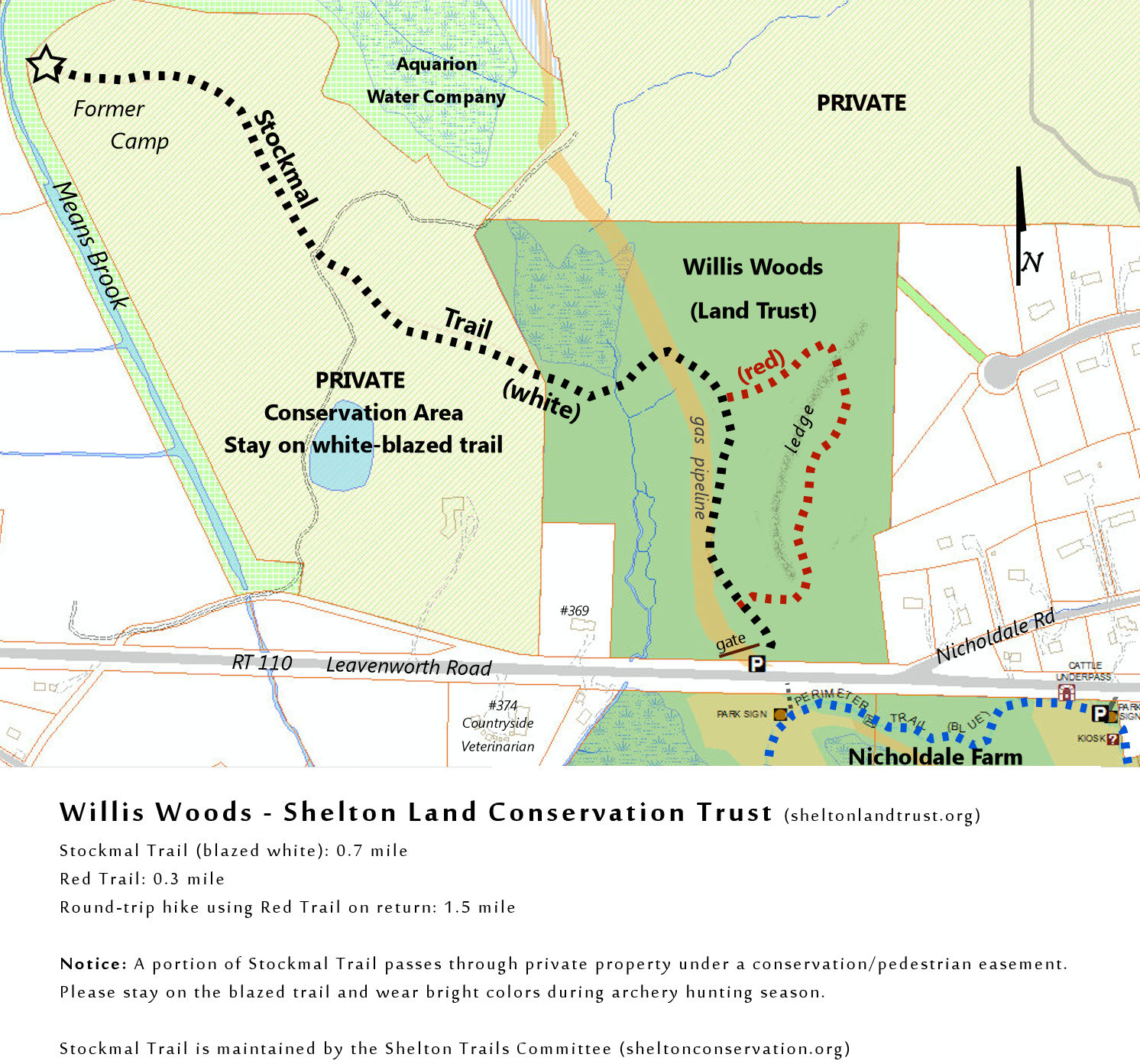 Willis
Woods is located on the north side of the highway across from
Nicholdale Farm, with limited parking just west of Nicholdale
Road at the gas pipeline crossing.
Willis
Woods is located on the north side of the highway across from
Nicholdale Farm, with limited parking just west of Nicholdale
Road at the gas pipeline crossing.
The City of Shelton's Trails Committee maintains two hiking
trails that link up with the Nicholdale/Willis Woods trail
network: Stockmal Trail (Willis Woods) and the Pearmain Path
(Nicholdale Farm). These two trails cross private property under
a land preservation agreement with the city and state.
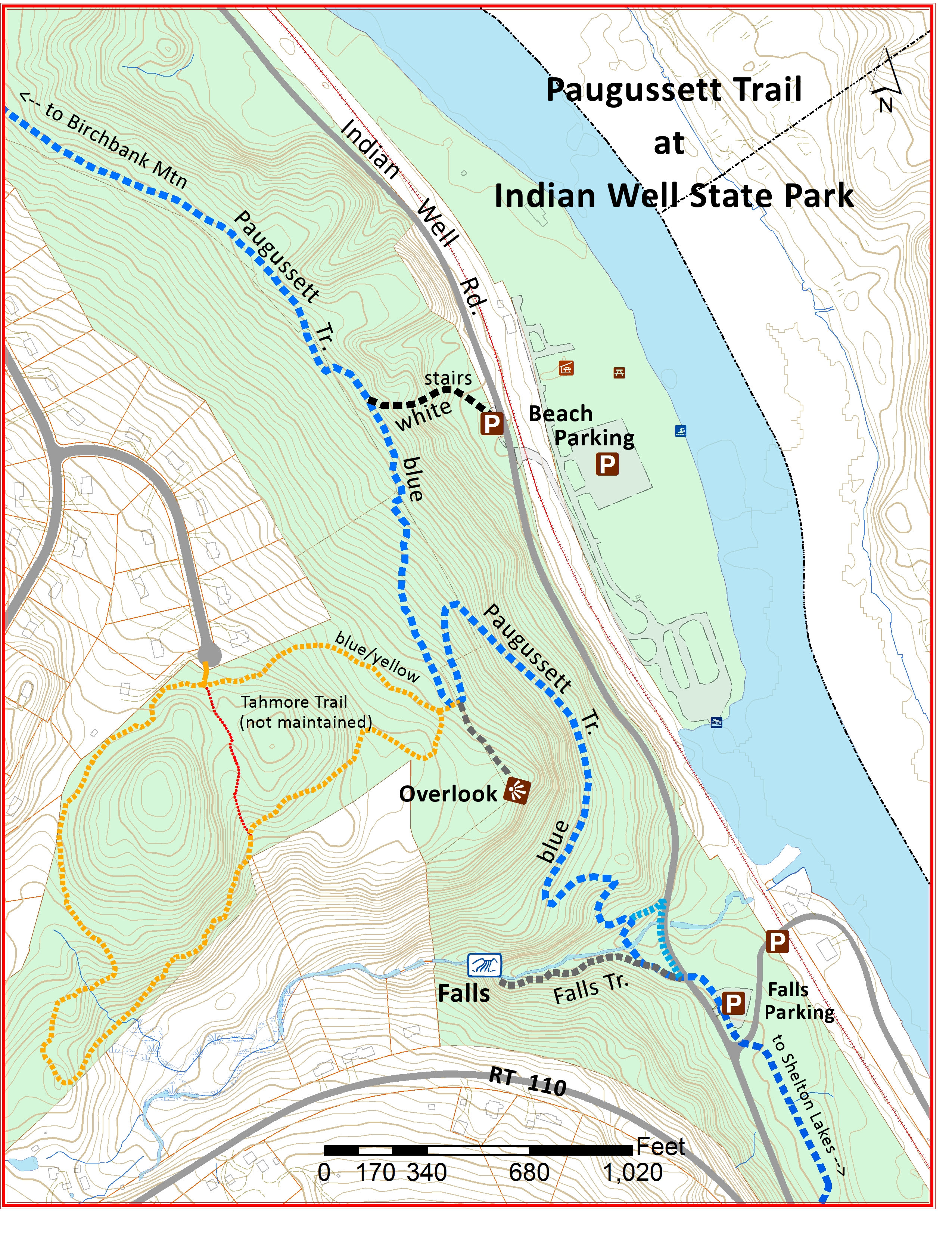
Tahmore Trail & Indian Well S.P.
Moderate difficulty with hills
Scenic overlook and Indian Well Falls
This popular CFPA network has been
upgraded substantially over the past few years. It may be
reached via Indian Well State Park or from the
Shelton Land Trust's Tahmore
property. The blue-blazed Paugussett Trail anchors the system. A
loop from the beach at Indian Well to the Falls is now possible
by returning on the blue/red Beach Cutoff trail. The
blue/yellow-blazed Tahmore Trail loops around the heights and is
the quieter part of the system. The Indian Well overlook is one
of the very best in Shelton. Off in the distance is the Yale
Boathouse, the Derby-Shelton dam and gatehouse, and tiny cars
crossing the Route 8 bridge. The overlook is located on the
blue/yellow loop a few hundred feet from the blue-blazed
Paugussett Trail. Mountain bikes are prohibited from these CFPA
trails.
[Map
PDF] for printing
[Map
JPG] for phones
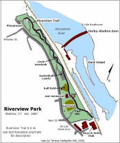
The Bluff Walk (Riverview Trail)
Moderate 0.6 mile
 [TRAIL
MAP - pdf] Many people are familiar with Riverview Park in downtown Shelton
but do not realize there is a very old hiking trail that begins
behind the playground. The trail is benched into the side
of the river bluff among huge trees, eventually emerging at the
basketball courts. From that point it is a "virtual"
trail, going behind the first ball field, through the back of the
second ball field, and ending at the stone marker for Fort Hill
at the southern end of the park. The trail features
a spectacular overlook of the Derby-Shelton Dam at the Boy With
Fish statue, a certified Constitution Oak, and the Pootatuck
Fort Hill Marker. Click map to enlarge.
[TRAIL
MAP - pdf] Many people are familiar with Riverview Park in downtown Shelton
but do not realize there is a very old hiking trail that begins
behind the playground. The trail is benched into the side
of the river bluff among huge trees, eventually emerging at the
basketball courts. From that point it is a "virtual"
trail, going behind the first ball field, through the back of the
second ball field, and ending at the stone marker for Fort Hill
at the southern end of the park. The trail features
a spectacular overlook of the Derby-Shelton Dam at the Boy With
Fish statue, a certified Constitution Oak, and the Pootatuck
Fort Hill Marker. Click map to enlarge.
Paugussett ("Blue Dot") Trail
[Moderate to Challenging 14 miles total, (9 miles in Shelton)
View Paugussett Trail in a larger map
[ MAP for printing - updated 2016]
The Paugussett Trail begins at East Village Road in Monroe, heads east to Lake Zoar, then south to Webb Mountain Park, Birchbank Mountain (Shelton), Indian Well State Park, and a new section that leads to Shelton Lakes. Parts of this trail are challenging, with steep slopes and the occasional rock scramble or boulder climb. Total length is about 14 miles, and camping is allowed at Webb Mountain Park. CT Blue-Blazed hiking trails are generally closed to mountain biking, but bikes are allowed on the trail at Shelton Lakes.
Mileage (approximate) from Buddington Road going
north:
Nells Rock Trail 0.6
Eklund Wildflower Garden 1.3
Hope Lake 1.4
Silent Waters 2.1
Indian Well Falls Parking 4.6
Birchbank Mtn 6.6
Webb Mtn, Monroe 10.6
Cottage St. (near Lake Zoar) 12.3
Barnhill Road, Monroe 14 miles
Maps: [
PDF map for printing
]
[
Paugussett at Indian Well S.P. ]
Online map: Please allow a full minute for this Google Paugussett Overview Map to load. Once it's loaded, you can use it to obtain driving directions or use with a smart phone for turn by turn directions. You can also turn on contours or the satellite view. The trail route shown is approximate only, and we recommend that hikers purchase a copy of the CT Walk Book (West Edition), which contains hiking maps and descriptions of the older part of the trail from Indian Well to Monroe, as well as many other Blue-Blazed trails in Connecticut. Your purchase also supports CFPA, the nonprofit organization that maintains all the Blue-Blazed Trails in Connecticut.
Background: The Paugussett Trail was a CCC project during the Great Depression and at one time stretched from Lake Zoar in Monroe all the way to Roosevelt Forest in Stratford. Some time prior to 1971, the trail south of Indian Well State Park was abandoned after it was cut off by new subdivisions, and the north end of the trail absorbed a reminent of the Pomperaug Trail in Monroe.
Paugussett Restoration: In the early 1990s, the Conservation Commission and Open Space Committee began planning for the restoration of the Paugussett Trail south to the town line. A corridor of land was gradually acquired, allowing for the trail to be routed completely on public land. The Shelton Trails Committee constructed the new trail route from Indian Well State Park to Buddington Road in the Shelton Lakes Greenway, which the exception of a section at Mayflower Lane, which is bypassed by walking on the pavement for 1000 feet. The Trails Committee will continue to extend the trail to the Stratford town line if possible.